MiNe's


Firstly, I would like to share about my story and my lovely toys, the Yamaha 135lc and the Honda Civic EJ. Both of it are are my lovely transport since I was young. Since I was 10 years old, I am very excited with cars and motorcycles especially it is a bike. A big cc engine bike and a modified engine cars are my favourites. Wow! I am very excited about it. Although some people said when someone going to modified a car or something to fulfill their passion with speed.. it actually wrong for me because, yes many people like to modified cars to make them go faster but in my mind, I didn't think to have more speed because I am a person who like to hear the sound of a big engine. If who is really expert about the sound only can tell us what is the meaning of an engine's sound. It is very nice to hear because every engine has it own story that make them have different sound and I love it. When I was 19 years old, I get my own Yamaha 135 lc and when I'm 20, I has get my lovely car the Civic EJ. At my 135lc, there was a number 11. I know people will wondering what is the meaning of the 11. It actually is my lovely person number. If I took a ride lonely, the number 11 will make me feel that she is with me..huhu =D ..Back to the stoy, I am very take a good care and love my toys like I take care of a child.=)


My Activities..

Now, let me shares and tells my hobbies and activities.. hope Enjoy it (n_n)

Sunday 27 November 2011

MiNe's Little Business.. (GARMIN GPS)

GARMIN GPS
The Garmin Nuvi 1390 is an ultra-thin, easy to use, widescreen sat-nav. It features Lane Assist and Junction View for supreme route awareness. It also includes Bluetooth wireless technology for hands-free phone calls, pan-European premium traffic alerts and ecoRoute to calculate a more fuel-efficient route. 


The Garmin Nuvi 1390 has a unique speed camera warning system to help you drive safely and an optional CityXplorer download which will even direct you via public transport (information varies between cities) or give you instructions for walking to your destination in stead of using your car so you can use your sat-nav anywhere.

Malaysia Price : RM 600.00
MiNe's Price    : RM 450.00

MiNe's Little Business..


Nokia Bluetooth Stereo Headset BH-503
Nokia Bluetooth Stereo Headset BH-503 – Music to your ears

Ideal for individuals who enjoy music with their active lifestyle, the Nokia Bluetooth Stereo Handset BH-503 brings you music and call handling - all in wireless freedom. Enjoy style in comfort with music played back in Hi-Fi stereo quality coupled with an ergonomic neckband design.
With a Nokia Bluetooth Stereo Headset BH-503 you can:
  • enjoy high-quality stereo sound streamed from your compatible phone
  • stay comfortably in style with over the ear and an ergonomic neckband design 
  • control the music player and manage your calls with the integrated media keys
  • save time with fast charging
This charger complies with IEC/EN 62684: Interoperability Specifications of Common External Power Supply for use with Data-Enabled Mobile Telephones.

Specifications are subject to change without notice.

The availability of particular products and services may vary by area. 

Operations, services and some features may be dependent on the network and/or SIM card as well as on the compatibility of the devices used and the content formats supported. Some services are subject to a seperate charge.
Also be used not only for nokia's phone, but also with other phone that has bluetooth.

 For more information, call me and get the best price. Hurry while stock last.

Malaysia Price : RM 230.00
MiNe's Price   : RM 170.00

So, what you waiting for??? Come and get it =)

BLUETOOTH..


Bluetooth is a proprietary open wireless technology standard for exchanging data over short distances (using short wavelength radio transmissions in the ISM band from 2400-2480 MHz) from fixed and mobile devices, creating personal area networks (PANs) with high levels of security. Created by telecoms vendor Ericsson in 1994,[1] it was originally conceived as a wireless alternative to RS-232 data cables. It can connect several devices, overcoming problems of synchronization.
Bluetooth is managed by the Bluetooth Special Interest Group, which has more than 15,000 member companies in the areas of telecommunication, computing, networking, and consumer electronics. The SIG oversees the development of the specification, manages the qualification program, and protects the trademarks. To be marketed as a Bluetooth device, it must be qualified to standards defined by the SIG. A network of patents is required to implement the technology and are only licensed to those qualifying devices; thus the protocol, whilst open, may be regarded as proprietary.

Name and logo

The Bluetooth logo is a bind rune merging the Younger Futhark runes Runic letter ior.svg (Hagall) (ᚼ) and Runic letter berkanan.svg (Bjarkan) (ᛒ), Harald's initials.

Implementation

Bluetooth uses a radio technology called frequency-hopping spread spectrum, which chops up the data being sent and transmits chunks of it on up to 79 bands (1 MHz each; centered from 2402 to 2480 MHz) in the range 2,400-2,483.5 MHz (allowing for guard bands). This range is in the globally unlicensed Industrial, Scientific and Medical (ISM) 2.4 GHz short-range radio frequency band.

Originally Gaussian frequency-shift keying (GFSK) modulation was the only modulation scheme available; subsequently, since the introduction of Bluetooth 2.0+EDR, π/4-DQPSK and 8DPSK modulation may also be used between compatible devices. Devices functioning with GFSK are said to be operating in basic rate (BR) mode where an instantaneous data rate of 1 Mbit/s is possible. The term Enhanced Data Rate (EDR) is used to describe π/4-DPSK and 8DPSK schemes, each giving 2 and 3 Mbit/s respectively. The combination of these (BR and EDR) modes in Bluetooth radio technology is classified as a "BR/EDR radio".
Bluetooth is a packet-based protocol with a master-slave structure. One master may communicate with up to 7 slaves in a piconet; all devices share the master's clock. Packet exchange is based on the basic clock, defined by the master, which ticks at 312.5 µs intervals. Two clock ticks make up a slot of 625 µs; two slots make up a slot pair of 1250 µs. In the simple case of single-slot packets the master transmits in even slots and receives in odd slots; the slave, conversely, receives in even slots and transmits in odd slots. Packets may be 1, 3 or 5 slots long but in all cases the master transmit will begin in even slots and the slave transmit in odd slots.
Bluetooth provides a secure way to connect and exchange information between devices such as faxesmobile phonestelephoneslaptopspersonal computersprintersGlobal Positioning System(GPS) receivers, digital cameras, and video game consoles.

Communication and connection

A master Bluetooth device can communicate with a maximum of seven devices in a piconet (an ad-hoc computer network using Bluetooth technology), though not all devices support this limit. The devices can switch roles, by agreement, and the slave can become the master (for example, a headset initiating a connection to a phone will necessarily begin as master, as initiator of the connection; but may subsequently prefer to be slave).
The Bluetooth Core Specification provides for the connection of two or more piconets to form a scatternet, in which certain devices simultaneously play the master role in one piconet and the slave role in another.
At any given time, data can be transferred between the master and one other device (except for the little-used broadcast mode). The master chooses which slave device to address; typically, it switches rapidly from one device to another in a round-robin fashion. Since it is the master that chooses which slave to address, whereas a slave is (in theory) supposed to listen in each receive slot, being a master is a lighter burden than being a slave. Being a master of seven slaves is possible; being a slave of more than one master is difficult. The specification is vague as to required behaviour in scatternets.
Many USB Bluetooth adapters or "dongles" are available, some of which also include an IrDA adapter. Older (pre-2003) Bluetooth dongles, however, have limited capabilities, offering only the Bluetooth Enumerator and a less-powerful Bluetooth Radio incarnation. Such devices can link computers with Bluetooth with a distance of 100 meters, but they do not offer as many services as modern adapters do.

Uses

Bluetooth is a standard wire-replacement communications protocol primarily designed for low power consumption, with a short range (power-class-dependent, but effective ranges vary in practice; see table below) based on low-cost transceiver microchips in each device.Because the devices use a radio (broadcast) communications system, they do not have to be in visual line of sight of each other, however a quasi optical wireless path must be viable.
ClassMaximum permitted powerRange
(m)
(mW)(dBm)
Class 110020~100
Class 22.54~10
Class 310~5
The effective range varies due to propagation conditions, material coverage, production sample variations, antenna configurations and battery conditions. In most cases the effective range of class 2 devices is extended if they connect to a class 1 transceiver, compared to a pure class 2 network. This is accomplished by the higher sensitivity and transmission power of Class 1 devices.
VersionData rateMaximum application throughput
Version 1.2Mbit/s0.7 Mbit/s
Version 2.0 + EDR3 Mbit/s2.1 Mbit/s
Version 3.0 + HSUp to 24 Mbit/sSee Version 3.0+HS.
Version 4.0Up to 24 Mbit/sSee Version 3.0+HS.
While the Bluetooth Core Specification does mandate minimums for range, the range of the technology is application specific and is not limited. Manufacturers may tune their implementations to the range needed to support individual use cases.

WAAS..

WAAS..

What is WAAS?

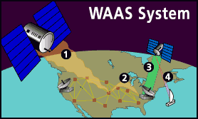
WAAS Diagram
You've heard the term WAAS, seen it on packaging and ads for Garmin® products, and maybe even know it stands for Wide Area Augmentation System. Okay, so what the heck is it? Basically, it's a system of satellites and ground stations that provide GPS signal corrections, giving you even better position accuracy. How much better? Try an average of up to five times better. A WAAS-capable receiver can give you a position accuracy of better than three meters 95 percent of the time. And you don't have to purchase additional receiving equipment or pay service fees to utilize WAAS.

The origins of WAAS

The Federal Aviation Administration (FAA) and the Department of Transportation (DOT) are developing the WAAS program for use in precision flight approaches. Currently, GPS alone does not meet the FAA's navigation requirements for accuracy, integrity, and availability. WAAS corrects for GPS signal errors caused by ionospheric disturbances, timing, and satellite orbit errors, and it provides vital integrity information regarding the health of each GPS satellite.

How it Works

WAAS consists of approximately 25 ground reference stations positioned across the United States that monitor GPS satellite data. Two master stations, located on either coast, collect data from the reference stations and create a GPS correction message. This correction accounts for GPS satellite orbit and clock drift plus signal delays caused by the atmosphere and ionosphere. The corrected differential message is then broadcast through one of two geostationary satellites, or satellites with a fixed position over the equator. The information is compatible with the basic GPS signal structure, which means any WAAS-enabled GPS receiver can read the signal.

Who benefits from WAAS?

Currently, WAAS satellite coverage is only available in North America. There are no ground reference stations in South America, so even though GPS users there can receive WAAS, the signal has not been corrected and thus would not improve the accuracy of their unit. For some users in the U.S., the position of the satellites over the equator makes it difficult to receive the signals when trees or mountains obstruct the view of the horizon. WAAS signal reception is ideal for open land and marine applications. WAAS provides extended coverage both inland and offshore compared to the land-based DGPS (differential GPS) system. Another benefit of WAAS is that it does not require additional receiving equipment, while DGPS does.
Other governments are developing similar satellite-based differential systems. In Asia, it's the Japanese Multi-Functional Satellite Augmentation System (MSAS), while Europe has the Euro Geostationary Navigation Overlay Service (EGNOS). Eventually, GPS users around the world will have access to precise position data using these and other compatible systems.

It just keeps getting better

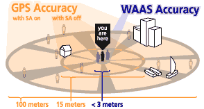
100 meters: Accuracy of the original GPS system, which was subject to accuracy degradation under the government-imposed Selective Availability (SA) program.
WAAS Accuracy Diagram
15 meters: Typical GPS position accuracy without SA.
3-5 meters: Typical differential GPS (DGPS) position accuracy.
< 3 meters: Typical WAAS position accuracy.

GPS..

GPS

What is GPS?

satellite
The Global Positioning System (GPS) is a satellite-based navigation system made up of a network of 24 satellites placed into orbit by the U.S. Department of Defense. GPS was originally intended for military applications, but in the 1980s, the government made the system available for civilian use. GPS works in any weather conditions, anywhere in the world, 24 hours a day. There are no subscription fees or setup charges to use GPS.

How it works

GPS satellites circle the earth twice a day in a very precise orbit and transmit signal information to earth. GPS receivers take this information and use triangulation to calculate the user's exact location. Essentially, the GPS receiver compares the time a signal was transmitted by a satellite with the time it was received. The time difference tells the GPS receiver how far away the satellite is. Now, with distance measurements from a few more satellites, the receiver can determine the user's position and display it on the unit's electronic map.
GPS Screens
A GPS receiver must be locked on to the signal of at least three satellites to calculate a 2D position (latitude and longitude) and track movement. With four or more satellites in view, the receiver can determine the user's 3D position (latitude, longitude and altitude). Once the user's position has been determined, the GPS unit can calculate other information, such as speed, bearing, track, trip distance, distance to destination, sunrise and sunset time and more.

How accurate is GPS?

Today's GPS receivers are extremely accurate, thanks to their parallel multi-channel design. Garmin's 12 parallel channel receivers are quick to lock onto satellites when first turned on and they maintain strong locks, even in dense foliage or urban settings with tall buildings. Certain atmospheric factors and other sources of error can affect the accuracy of GPS receivers. Garmin® GPS receivers are accurate to within 15 meters on average.
GPS Signals
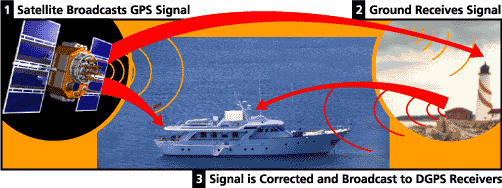
Newer Garmin GPS receivers with WAAS (Wide Area Augmentation System) capability can improve accuracy to less than three meters on average. No additional equipment or fees are required to take advantage of WAAS. Users can also get better accuracy with Differential GPS (DGPS), which corrects GPS signals to within an average of three to five meters. The U.S. Coast Guard operates the most common DGPS correction service. This system consists of a network of towers that receive GPS signals and transmit a corrected signal by beacon transmitters. In order to get the corrected signal, users must have a differential beacon receiver and beacon antenna in addition to their GPS.
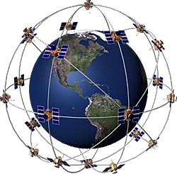
Satellite Diagram

The GPS satellite system

The 24 satellites that make up the GPS space segment are orbiting the earth about 12,000 miles above us. They are constantly moving, making two complete orbits in less than 24 hours. These satellites are travelling at speeds of roughly 7,000 miles an hour.
GPS satellites are powered by solar energy. They have backup batteries onboard to keep them running in the event of a solar eclipse, when there's no solar power. Small rocket boosters on each satellite keep them flying in the correct path.
Here are some other interesting facts about the GPS satellites (also called NAVSTAR, the official U.S. Department of Defense name for GPS):
  • The first GPS satellite was launched in 1978.
  • A full constellation of 24 satellites was achieved in 1994.
  • Each satellite is built to last about 10 years. Replacements are constantly being built and launched into orbit.
  • A GPS satellite weighs approximately 2,000 pounds and is about 17 feet across with the solar panels extended.
  • Transmitter power is only 50 watts or less.

What's the signal?
GPS satellites transmit two low power radio signals, designated L1 and L2. Civilian GPS uses the L1 frequency of 1575.42 MHz in the UHF band. The signals travel by line of sight, meaning they will pass through clouds, glass and plastic but will not go through most solid objects such as buildings and mountains.
A GPS signal contains three different bits of information - a pseudorandom code, ephemeris data and almanac data. The pseudorandom code is simply an I.D. code that identifies which satellite is transmitting information. You can view this number on your Garmin GPS unit's satellite page, as it identifies which satellites it's receiving.
Ephemeris data, which is constantly transmitted by each satellite, contains important information about the status of the satellite (healthy or unhealthy), current date and time. This part of the signal is essential for determining a position.
The almanac data tells the GPS receiver where each GPS satellite should be at any time throughout the day. Each satellite transmits almanac data showing the orbital information for that satellite and for every other satellite in the system.
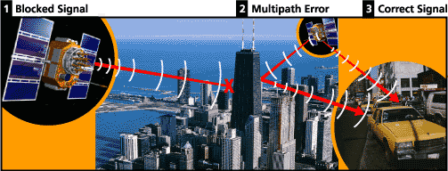
Blocked Signal Diagram

Sources of GPS signal errors

Factors that can degrade the GPS signal and thus affect accuracy include the following:
  • Ionosphere and troposphere delays - The satellite signal slows as it passes through the atmosphere. The GPS system uses a built-in model that calculates an average amount of delay to partially correct for this type of error.
  • Signal multipath - This occurs when the GPS signal is reflected off objects such as tall buildings or large rock surfaces before it reaches the receiver. This increases the travel time of the signal, thereby causing errors.
  • Receiver clock errors - A receiver's built-in clock is not as accurate as the atomic clocks onboard the GPS satellites. Therefore, it may have very slight timing errors.
  • Orbital errors - Also known as ephemeris errors, these are inaccuracies of the satellite's reported location.
  • Number of satellites visible - The more satellites a GPS receiver can "see," the better the accuracy. Buildings, terrain, electronic interference, or sometimes even dense foliage can block signal reception, causing position errors or possibly no position reading at all. GPS units typically will not work indoors, underwater or underground.
  • Satellite geometry/shading - This refers to the relative position of the satellites at any given time. Ideal satellite geometry exists when the satellites are located at wide angles relative to each other. Poor geometry results when the satellites are located in a line or in a tight grouping.
  • Intentional degradation of the satellite signal - Selective Availability (SA) is an intentional degradation of the signal once imposed by the U.S. Department of Defense. SA was intended to prevent military adversaries from using the highly accurate GPS signals. The government turned off SA in May 2000, which significantly improved the accuracy of civilian GPS receivers.